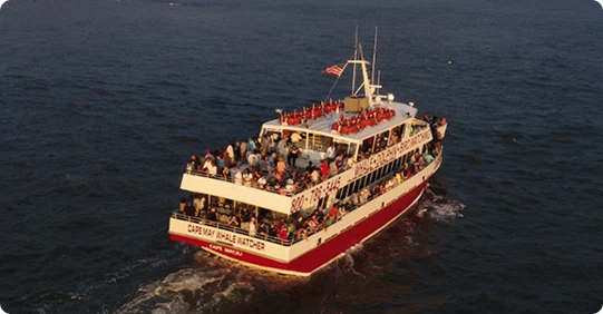


points of interest
You may see and hear about on your trip
Ocean Loop
Spicer’s Creek
Our trip begins on Spicers Creek, an excellent example of the salt marsh. This area is teeming with life. Many species of saltwater fish start out in the back bays. A variety of shore birds can be seen along the shores in this area, including Great Egrets, Snowy Egrets, Great Blue Herons, Laughing Gulls, Blackback gulls, Herring Gulls, and even Osprey.
Schellengers Landing
The Miss Chris Marina, originally called the Back Harbor Wharf, dates back to the 1800s when the Fisherman’s Express, a rail line from Philadelphia, PA, would drop fishermen in the area so they could head out on charter boats.
Cape May Canal
Connecting Delaware Bay with Cape May Harbor, the Cape May Canal is 3.5 miles in length. The Canal is man-made, constructed in 1942, during World War II so that our shipping would not have to go around Cape May Point, where they were being subjected to German U-Boat Attacks.
Garden State Parkway Bridge
This bridge marks the end of the Garden State Parkway, Mile Marker Zero. 140 Miles north of here is New York City.
Cape May Harbor
Cold Spring Harbor
Constructed between the years 1900 and 1908 the entire harbor is man-made, dredged out from over 500 acres of salt marsh, the spoils of which were used to backfill East Cape May.
Canyon Club Marina
Host of the Mid Atlantic Tournament, the richest marlin tournament in the world.
Utches Marina
Lobster House Fish House and Restaurant
This is where you can buy fresh fish right off the boats. Most of the boats tied up there today are offshore fishing draggers and scallop boats.
Nature Center of Cape May
Home to a wonderful lookout tower over Cape May Harbor as well as several touch tanks.
Corinthian Yacht Club of Cape May
Our local sailing organization. One of the oldest yacht clubs in the United States.
United States Coast Guard Base and Training Center
TRACEN Sector Delaware Bay.
United States Coast Guard Cutters
155-foot Angela McShann, Rollin Fritch, Lawrence Lawson, and 87-foot Cutters Mako, Finback, United States Coast Guard Small Boats 45 and 29.
Mad Viking Bar and Marina
Port Restaurant and Marina
Breezee Lee Marina
Lunds Seafood Docks
Two Mile Bridge
Sewells Point
Loran Tower
Cold Spring Inlet
The island of Wildwood
Diamond Beach
Wildwood Crest, New Jersey
With all those Beautiful Hotels built right out on the beach.
Ocean Towers #1 and #2
Start of the Wildwood Boardwalk
Wildwood Fishing Pier
Start of Wildwood Boardwalk on Cresse Avenue in Wildwood Crest
Wildwood Boardwalk
9771 feet long.
Morey Piers
Started as a small family-owned business and now has large businesses today.
Mariners Landing
North Wildwood Captain Jeff’s original summer home
Herford Inlet
Where Captain Jeff learned to boat, a closed inlet, closed to vessel navigation due to extreme shifting sand bars.
The Island of Cape May (Cape Island)
World War 2 Ammunition Bunkers
Established when the Coast Guard Base was a Naval Base.
The City of Cape May
A very historic city dating back to the whaling days and beyond. Originally a two-day trip down to Cape May from the original Capital of Philadelphia, the first day down to Mays Landing and the second day down to Cape May, by stagecoach.
Poverty Beach
Car Racing History Henry Ford and Gaston Chevrolet
Used to race their cars here, like in Daytona. The beaches here and in Daytona were much wider back then.
Bathing Suits History
Originally, only men would go bathing in the nude for health purposes. During Victorian times, ladies wanted to bathe at the beach, and they had to go to great lengths. They had horse-drawn bathing houses that would be lowered down to the surfline. Ladies would go into these and change into their bathing costumes, which they were clothed from head to foot. They had long woolen skirts, shoes, and hats. Eventually, this custom grew tiresome and hotels regulated bathing with flags. Women would go in the morning and men in the afternoon. It is said that the first co-ed bathing happened due to women being too frail to tackle the wild surf on their own, so they needed the men to help keep them from drowning.
East Cape May
Started in 1903 purchased for 200K by the East Cape May Development Corporation a group of investors from Pittsburgh PA. Their original plan was to build 5000 homes, however they fell short and fewer than 100 homes were built- these (Seasside cottages) homes stand as a laying testimony to their efforts.
La Mer Hotel
Peter Shields Inn
Constructed in 1907 for the president of the East Cape May Development Corporation. Its façade speaks of money and power- the most pretentious home built along the beachfront here in Cape May. It was the final home they built before going bankrupt.
Angel of the Sea
The history of Cape May City and the natural catastrophe that saved Cape May, that being the Great Nor’Easter of 1962, which destroyed the sea wall protecting the town, flooded the town for three days, and destroyed several of the old Victorian Homes. At this point, many land developers came to Cape May hoping to tear down the remaining old buildings and put up new modern structures, much like the Wildwoods. Then, a grassroots movement took hold known as MAC. Originally called the Mid-Atlantic Center for the Arts (MAC), now known as Cape May MAC for Museums, Arts, and Culture, MAC fought to preserve the history of Cape May, and their first battle was fought over the Emelynn Physic Estate (1879) which now serves as their headquarters and museum in down town Cape May. MAC, along with the hard-working local property owners and business owners, is solely responsible for the Cape May, NJ, we all get to enjoy today.
ICONA Cape May
Grand Hotel
Ocean Club Hotel
Mahalo Cape May
Montreal Cape May
Rhythm of the Sea
Sea Mist Inn
This next group of homes for several city blocks are all perfect examples of Victorian Architecture at its finest. All these homes were built between the 1860s-1870s. They are capped off by the white building with the red roof and red awning. This is the Sea Mist Inn, the most photographed home on the Cape May beachfront.
Cape May Convention Hall
The third convention hall to be built here in Cape May, the first two were lost to the Sea.
Avondale by the Sea
The Inn of Cape May
Our Lady Star of the Sea Church
Steeple visible.
Uncle Bill's Pancake House
Congress Hall
The Large Yellow building with white pillars and a grey roof: this is Congress Hall. This is the third Congress Hall to be built here; the first two were lost to fires. The Second Congress Hall was lost in the great November Fire of 1878. That same fire destroyed over 30 acres of downtown Cape May. The Third and present-day Congress Hall was built in 1879, using Brick for the exterior. It is L-shaped to maximize the Ocean Views. It features white oversized pillars and a wrap-around porch, trademarks of the Victorian hotels of its day.
Ocean View Restaurant
Second Street Jetty
Originally a favorite of the fishermen, many prize-winning Flounder, Sea Bass, Weakfish, and Tautog had been caught off the Second Street Jetty. Today, thanks to Beach Replenishment, the Second Street Jetty is practically landlocked, tho many surfers can be found enjoying this spot in a South West Swell day
The Cove
This stretch of beach runs from the end of Beach Drive all the way to Cape May Point. This stretch of beach is the southern edge of the South Cape May Meadows, a favorite of the birding community throughout the seasons. The waters of the Cove are a favorite of the Surfers in Cape May, and a favorite of the local Tamaneds Bottlenose dolphins, as this is where we see the highest number of new born calves being given birth each season.
South Cape May
Believe it or not, you are sailing over the top of the remains of South Cape May. All that is left are some of the streets and the foundations of some of the old homes, underneath of us, buried in the sand. South Cape May was originally marketed to the African American community here in Cape May. One land developer attempting to attract extra attention to South Cape May constructed a wooden and tin-sided elephant, a lot like Lucy the Elephant up in Margate, New Jersey. Ours was called the Light of Asia. It was built in 1885, however, it was torn down just 15 years later, due to a lack of maintenance.
World War II Gun Emplacement and Bunker
The large concrete structure up on the beach is a World War II gun emplacement and bunker. It originally housed two 155 mm seacoast artillery guns, with a twelve mile range. It is actually a satellite battery to a much larger military installation located in Cape Henlopen Delaware called Fort Miles which housed 12 and 16 inch guns, all designed to protect the mouth of Delaware Bay from attack.
